

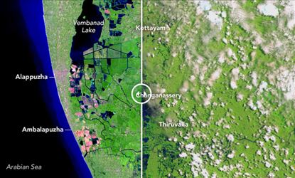

Accordingly following the heavy rains and flooding that wreaked havoc in Kerala, scientists at the National Aeronautics and Space Administration (NASA) has released images which show the state before and after the devastation occurred. Reports added in the image, one can see the heavily impacted areas of Pathanamthitta and Alappuzha as well as the neighboring district of Kottayam as a sea of blue, showing the extent of the flooding. Meanwhile the first image was taken on February 6 this year, while the second was taken on August 22.
Further NASA’s Operational Land Imager (OLI) on the Landsat 8 satellite took the images on February 6, while the second image was taken by European Space Agency’s satellite, Sentinel-2 and moreover the image taken after the floods shows what NASA calls “false-color,” after the waters had flooded the state. Moreover false color images show images in a different manner than how normal photographs would make them appear.
Reports stated that stark contrast can be observed in the two images, with
the second one showing an alarming rate of flooding. Moreover the water level, represented
in a dark blue color, is shown covering the green lands in the second image. Previously
NASA had released a video which showed the severity of the rainfall and noted
that the Western Ghats, the position of which enhances rainfall along the west
coast of India. Hence following the heavy rains which rampaged the state, over
3 lakh people have been forced to relocate to relief camps, of which 1,093 have
been set up in the state.

